Dye & Durham has announced a new integration between its Terrain property data platform and Nearmap, a leading provider of high-resolution aerial imagery. The integration gives Terrain users seamless access to Nearmap’s up-to-date aerial imagery directly within their existing parcel, title and geospatial workflows.
By combining property data with high-resolution aerial imagery, the integration enables faster and more accurate property planning, land analysis and risk assessment across the property, infrastructure and energy sectors.
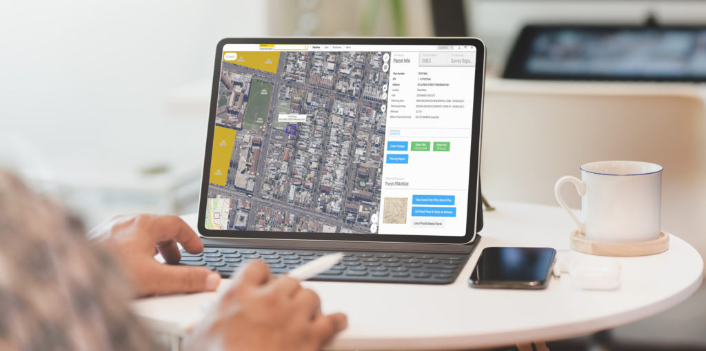
Access High-Resolution Aerial Imagery Within Terrain
The Nearmap integration allows Terrain users to visualise land parcels with greater precision by overlaying aerial imagery with property titles, cadastral boundaries and other geospatial data layers.
Professionals including surveyors, asset managers, utility providers, infrastructure developers and energy suppliers can use the imagery to gain deeper insights into terrain conditions, site constraints and land use.
This helps organisations make smarter property planning decisions while reducing the time required to gather and analyse spatial data.
Key Benefits of the Nearmap and Terrain Integration
Seamless access to Nearmap imagery: Existing Nearmap subscribers can access their aerial imagery directly within the Terrain platform without requiring additional tools, setup or software.
Choice of imagery provider: Terrain users can choose their preferred aerial imagery provider, selecting either Nearmap or Metromap based on their operational and project requirements.
Improved geospatial workflows: Users can access current and historical aerial imagery alongside property layers within Terrain, supporting workflows such as bulk title management, surveying field planning, infrastructure planning and spatial analysis.
Supporting Faster, Smarter Property Decisions
“This integration allows our customers to maximise the value of their existing Nearmap investment and work with the imagery source that best fits their operational requirements,” said Angus Scown, Director, Property Risk and Geospatial Intelligence at Dye & Durham.
“By bringing high-quality aerial imagery directly into the Terrain platform, we are helping professionals make faster and more informed property planning decisions with greater confidence.”
Availability
The Nearmap integration is now available to all Terrain users with an active Nearmap subscription, providing a streamlined way to incorporate high-resolution aerial imagery into property planning, surveying and title management workflows.